

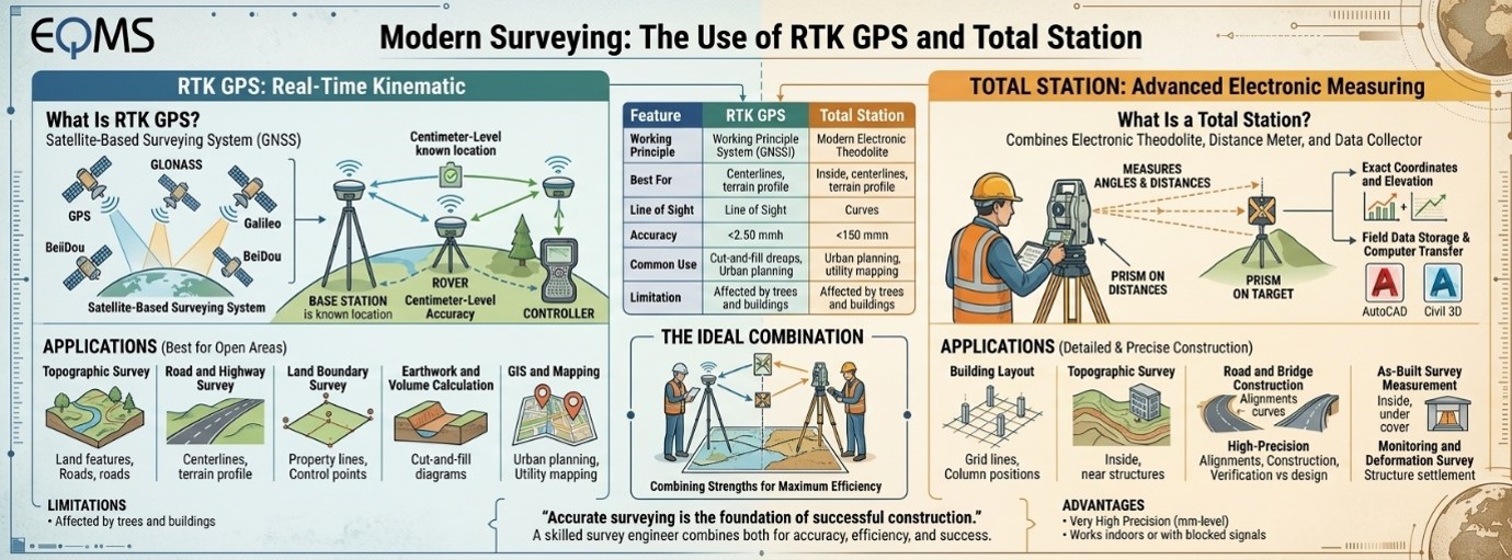
Surveying is among the most significant activities involved
in construction, land development, road designing, bridge construction, and
many other infrastructural ventures. Proper surveying ensures that the
location, elevation, distance, and the nature of the land can be known by
engineers and architects. Traditionally, the major instruments used in
surveying included chain tape, compass, and theodolites. But today, surveying
has been revolutionized through use of technological instruments such as RTK GPS
and Total Station.
Surveying has been revolutionized through use of
technological instruments such as RTK GPS and Total Station. The modern
technological devices used ensure accurate measurement, reduced fieldwork, and
better construction projects.
What Is RTK
GPS?
RTK is an acronym for Real-Time Kinematic. RTK GPS refers to
a type of surveying system that utilizes GNSS satellites to determine positions
of objects on the Earth surface using GPS, GLONASS, Galileo and/or BeiDou
constellations. The system is basically made up of two elements.
RTK GPS consists of two basic elements, namely: A base
station and a rover. Base station is located at a known point and provides
correction information to the rover; consequently, the rover is able to compute
extremely precise coordinates. Under appropriate circumstances, RTK GPS is
capable of achieving a precision of about one centimeter.
What Is a
Total Station?
The Total Station is a surveying instrument made up of an
electronic theodolite, electronic distance meter, and data collector. It
measures the horizontal and vertical angles and the distances of points from a
certain target or prism.
Once the measurements have been collected, the Total Station
computes the precise coordinates and elevations of the points. Contemporary
Total Stations are capable of storing field data, computing results, and
transferring the information directly to computer programs like AutoCAD and
Civil 3D.
Total Stations are commonly applied for construction layout,
building foundations, roads, structures, and other surveys.
Applications
of RTK GPS in Modern Surveying
RTK GPS is highly effective when surveying large and open
areas. It is commonly used in the following activities:
- v
Topographic Survey
- v
RTK GPS can quickly collect the coordinates and
elevations of natural and man-made features, including roads, rivers,
buildings, trees, and utility lines.
- v
Road and Highway Survey
- v
Survey engineers use RTK GPS to establish
centerlines, collect terrain data, and determine the existing ground profile
for road construction.
- v
Land Boundary Survey
- v
RTK GPS helps determine property boundaries and
locate important control points with high accuracy.
- v
Earthwork and Volume Calculation
- v
By collecting ground points, surveyors can
calculate cut-and-fill quantities for excavation, embankment, and land
development projects.
- v
GIS and Mapping
RTK GPS is also used to collect accurate geographic data for
mapping, urban planning, utility mapping, and environmental studies.
Applications
of Total Station in Modern Surveying
Total Stations are particularly useful for detailed and
precise work, especially on construction sites.
- v
Building Layout
- v
Topographic Survey
- v
Surveyors use Total Stations to mark grid lines,
column positions, foundation corners, walls, and other structural elements.
- v
Road and Bridge Construction
- v
They are used to establish alignments, set out
curves, transfer elevations, and position bridge components accurately.
- v
As-Built Survey
- v
A Total Station helps verify whether completed
construction work has been built according to the approved design drawings.
- v
High-Precision Measurement
- v
Total Stations are useful in areas where
satellite signals are blocked, such as inside buildings, near tall structures,
or under dense vegetation.
- v
Monitoring and Deformation Survey
Engineers use Total Stations to monitor the movement or
settlement of buildings, bridges, dams, towers, and other structures.
RTK GPS and
Total Station: Key Differences
|
Feature |
RTK GPS |
Total
Station |
|
Working Principle |
Satellite signal |
Angle and distance
measurement |
|
Best For |
Open areas |
Construction and
detailed work |
|
Line of Sight |
Not always required |
Required |
|
Accuracy |
Centimeter-level |
Very high precision
(mm-level) |
|
Common Use |
Mapping and
topographic survey |
Mapping and
topographic survey |
|
Limitation |
Affected by trees
and buildings |
Requires a clear
line of sight between the instrument and target. |
RTK GPS and Total Station have emerged as vital surveying
instruments in today’s world. RTK GPS is useful for its rapid and accurate
positioning in wide and open areas whereas Total Station is good at offering
highly precise readings for construction purposes. Both instruments have their
own set of advantages and disadvantages, and one has to choose an instrument
according to the nature and requirements of the work at hand.
An efficient survey engineer must be aware of the
capabilities and limitations of these two surveying instruments and how they
may be used effectively in combination for accurate results and completion of
modern surveying and construction projects.
"Surveying
with precision is the basis of successful construction."
Share this page via